Horn
Island Via Ocean Springs MS
by Bob Mercer rmercer@telocity.com Wrk 504-728-4263 Hm
985-652-6484
 Trip
Description: Horn Island, one in the chain of the Gulf Islands National
Seashore, is too large and interesting for a brief description. The beaches
are beautiful, white sand, with the typical dunes you find on barrier islands.
There are lots of pine trees and scrub oak with sea oats near the shore
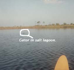
and areas of marsh inland. There are several lagoons that can give you an
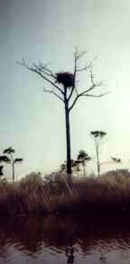
enchanting view of wildlife. Osprey nests dot the sky from their lofty,
pine perches and fish abound. I was surprised to even see an alligator.
I thought it would be too salty for them. These lagoons are a paddling paradise.
The water is too shallow for almost any kind of powerboat to enter. Take
note of landmarks when you enter a lagoon. Finding your way back out can
take some time, otherwise. Then again, it is a pleasant place to lose your
self for a few hours.
Trip
Description: Horn Island, one in the chain of the Gulf Islands National
Seashore, is too large and interesting for a brief description. The beaches
are beautiful, white sand, with the typical dunes you find on barrier islands.
There are lots of pine trees and scrub oak with sea oats near the shore
and areas of marsh inland. There are several lagoons that can give you an
enchanting view of wildlife. Osprey nests dot the sky from their lofty,
pine perches and fish abound. I was surprised to even see an alligator.
I thought it would be too salty for them. These lagoons are a paddling paradise.
The water is too shallow for almost any kind of powerboat to enter. Take
note of landmarks when you enter a lagoon. Finding your way back out can
take some time, otherwise. Then again, it is a pleasant place to lose your
self for a few hours.
 Notes:
The trip is not one Id recommend for a beginner to take solo. It
is an open water crossing that includes one of the busier commercial waterways
(The Intracoastal Waterway). The water in the Sound is generally not too
rough, but it can kick up rather quickly from a squall or wind change.
If the weather is nice, the paddle is not too severe. It is only a little
over six miles from the put-in to the island, but you will want to spend
time in the lagoons as well. I recommend an over-nighter to really see
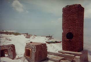
the place. However, you may not stay near the ruins by the west end. There
was a fire near there and it is restricted until the area has a chance
to recover.
Notes:
The trip is not one Id recommend for a beginner to take solo. It
is an open water crossing that includes one of the busier commercial waterways
(The Intracoastal Waterway). The water in the Sound is generally not too
rough, but it can kick up rather quickly from a squall or wind change.
If the weather is nice, the paddle is not too severe. It is only a little
over six miles from the put-in to the island, but you will want to spend
time in the lagoons as well. I recommend an over-nighter to really see
the place. However, you may not stay near the ruins by the west end. There
was a fire near there and it is restricted until the area has a chance
to recover.
Best times for this trip are spring and fall. Mid-summer heat can be a problem. Also be prepared to battle mosquitoes, gnats and sand flies. Bring lots of sun-block. Stingrays are common. Just remember to slide your feet instead of taking steps while wading.
Directions:
The trip is just over 100 miles from Metairie, Here are the directions
from MapPoint.
Summary: 107.1
miles (1 hour, 57 minutes)
|
Time |
Mile |
Instruction |
For |
Toward |
 |
|
9:00 AM |
0.0 |
Depart I-10 Exit 229 on Ramp (West) |
0.1 mi |
Bonnabel Blvd |
|
|
9:02 AM |
0.5 |
Merge onto I-10 (East) |
0.8 mi |
||
|
9:03 AM |
1.3 |
Continue (East) on I-610 |
4.4 mi |
I-610 / Slidell |
|
|
9:08 AM |
5.6 |
At I-610 Exit 4, turn off onto Ramp |
0.5 mi |
Louisa St / Almonaster Blvd |
|
|
9:09 AM |
6.2 |
Merge onto I-10 (North-East) |
92.8 mi |
||
|
9:44 AM |
41.6 |
Entering Mississippi |
|||
|
10:39 AM |
99.0 |
At I-10 Exit 57, turn off onto Ramp |
0.3 mi |
||
|
10:39 AM |
99.3 |
Merge onto SR-57 (South) |
3.1 mi |
||
|
10:45 AM |
102.3 |
Turn RIGHT (West) onto Old Spanish Trail |
0.1 mi |
||
|
10:46 AM |
102.5 |
Turn LEFT (South) onto Hammill Farm Rd |
1.0 mi |
||
|
10:48 AM |
103.5 |
Turn LEFT (East) onto Fountainbleau Rd |
0.3 mi |
||
|
10:49 AM |
103.7 |
Bear RIGHT (South) onto Belle Fountaine Rd |
0.4 mi |
||
|
10:50 AM |
104.1 |
Continue (South) on Belle Fountain Dr [Belle Fontaine Rd] |
0.9 mi |
||
|
10:52 AM |
105.0 |
Continue (South) on Elm St |
43 yds |
||
|
10:52 AM |
105.0 |
Bear LEFT (South-East) onto Main St |
1.7 mi |
||
|
10:56 AM |
106.7 |
Turn RIGHT (West) onto S Belle Fountaine Dr [E Belle Fountain Rd] |
0.3 mi |
||
|
10:57 AM |
107.0 |
Turn LEFT (South) onto Local road(s) |
153 yds |
Not sure about this distance, but you cant miss the water tower |
|
|
10:57 AM |
107.1 |
Arrive at Public Beach by Lighthouse (actually a water tower). |
That looks like a lighthouse. |